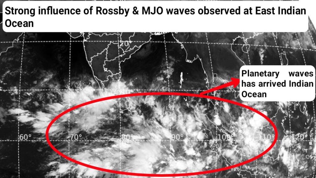
TamilNadu beloved Northeast monsoon so far not showed vigorous activity. And the time has arrived, at last the king “Madden Julian Oscillation” and the hero “Equatorial Rossby” waves has arrived East Indian Ocean. As discussed earlier, all other major giants like “Atlantic ocean and Pacific Ocean” has showing probable shutdown period for next two weeks. Hence, things slowly turning favourable for Vigorous Northeast monsoon phase between Nov 26th and Dec 5th, 2024.
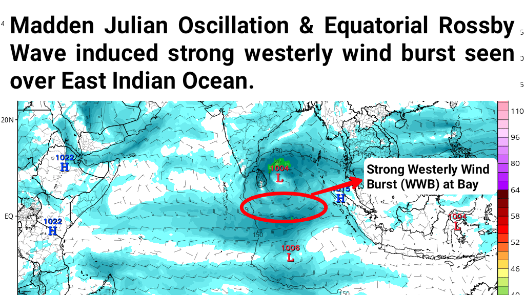
Under the influence of favourable planetary wave supports, westerly wind burst seems strengthening further at Indian Ocean from 25th Nov. Along with that streamlined easterlies flow also arriving from Pacific Ocean. This brings the best scenario to the possibility for the rain bearing system.
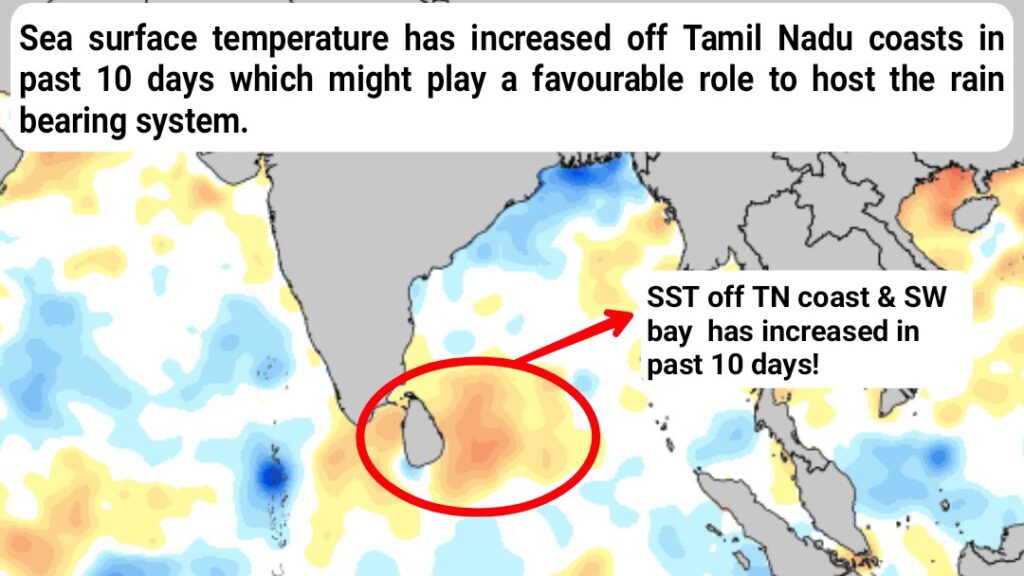
Sea surface temperature over TamilNadu coastal region & southwest Bay of Bengal has showing warming trend in past 10 days. It might play the major role with the upcoming system.
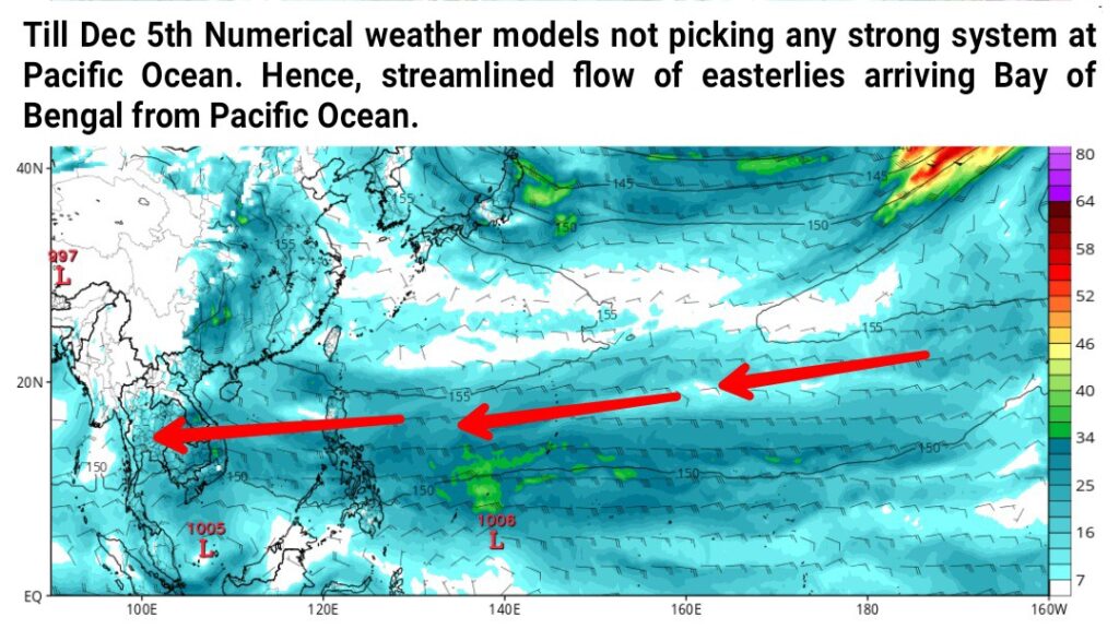
As planetary waves staying at East Indian Ocean & Maritime continent for next two weeks. Numerical weather models not indicating any major typhoon activities over Pacific Ocean until Dec 5th, 2024. Hence, streamlined flow of easterlies continues to arriving Bay of Bengal for next two weeks.
let’s come to the conclusion, under the above favourable scenarios a fresh low pressure area likely to form over Sumatra coasts during next 72 hrs. It likely to intensify further into well marked low & depression further will move west-northwest direction towards North coastal Tamilnadu & Delta region.

It’s too early to talk about landfall location but probable impact going to be entire North coastal Tamilnadu & Delta districts like Chennai to Nagapattinam zone. Districts like Nagapattinam, Karaikal, Thiruvarur, Thanjavur, Mayiladuthurai, Cuddalore, Pudhucherry, Villupuram, Chengalpet, Kanchipuram, Chennai, Thiruvallur coastal stretch very likely to see it’s peak & vigorous monsoon phase during Nov 26-30th, 2024. Scattered heavy showers likely to be there on 23rd & 24th Nov itself due to easterly wave. System based rains expected to pickup from late night hours of Nov 25th at delta coasts initially and then spread towards north coastal Tamilnadu by Nov 26th, 2024.
When we comes to landfall, it’s most likely to be between Chennai and Nagapattinam. The possibility one is “this system to cross central Tamilnadu coasts between Pudhucherry and Kodiyakarai close to Nagapattinam/Mayiladuthurai coasts as a marginal cyclone category without any stalling scenario.
Second possibility much interesting than first “In that case system, likely move closer to delta coasts & stalls for a day with rapid intensification into Severe cyclonic storm then take northwest movement to Cuddalore & Pudhucherry region.
In both cases, it won’t make any wind issues only intense extreme rains in short period is a big concern. If the first scenario evolves rains likely to start by Nov 23rd and peak rainy day on 26th & 27th (Probably 24 hrs time frame). Second scenario evolves means rains likely to start by Nov and peak rains days during 26th to 28th (Probably 48-72 hrs time frame).
Overall it’s going to be Massive rain filled system for North coastal & delta region. South Tamilnadu & Interiors also can get rains when the system makes landfall & probably with pull effect rains. So , lock the period Nov 26th to Dec 5th,
More updates to follow, stay tune! “If it’s not now, it’s gonna never!”
