Bloggers and weather enthusiasts were in a desperate situation due to November’s weak start, and now the month is all ready to demonstrate it’s power. Tamil Nadu, Pudhucherry, and parts of South Andhra Pradesh are anticipated to see heavy monsoon rainfall from November 11 to November 15, 2024, due to the second round of the Northeast monsoon. From November 11th to November 14th, 2024, north coastal districts and delta regions, including “Chennai, Thiruvallur, Kanchipuram, Chengalpet, Villupuram, Cuddalore, Mayiladuthurai, Nagapattinam, Thiruvarur, Thanjavur, and Pudhucherry, Karaikal dts, are likely to experience widespread heavy to very heavy rainfall with one or two extremely heavy rains.”

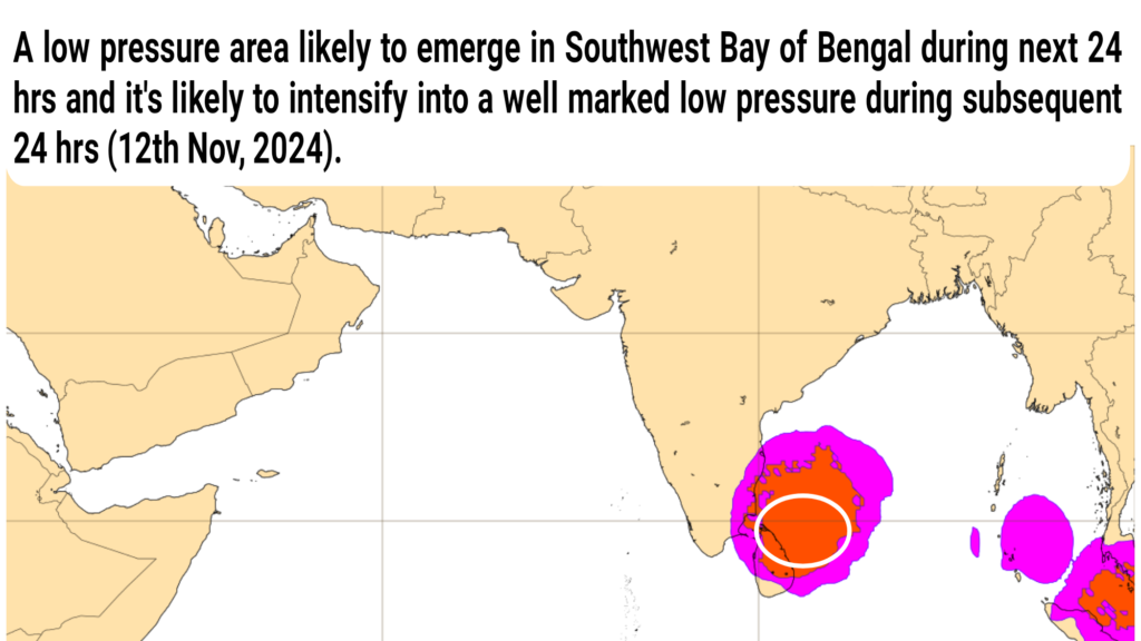
The “East Indian Ocean” has begin to be influenced by the Equatorial Rossby wave, the hero of the “Tropical planetary waves.” Additionally, it is the antecedent wave of King “Madden Julian Oscillation”. There are currently two circulations battling for survival—one near the shores of Myanmar and the other in the southwest Bay of Bengal—and it might be time for them to merge and leads a fresh low pressure system over the southwest Bay of Bengal by next 24 hrs.
This LPS (Low pressure system) unlikely to become a cyclone but with the support of Rossby wave, It likely intensify into a well marked low pressure area (WML) over Delta coasts by Nov 12th, 2024 and results active monsoon conditions during upcoming days.
Rains expected to start initially at Thiruvallur and Chennai dts by early part of Nov 11th and then spread to remaining north coastal & delta districts by later part of Monday (Nov 11th,2024).
From November 12th, this spell will spread to interiors which next to coastal like Ranipet, Thiruvanamalai, Kallakuruchi, Villupuram West, Perambalur, Ariyalur, and Trichy. From November 14th, it will spread to southern districts like Thuthucorin, Thirunelveli, Kanyakumari, Madurai, Theni, Tenkasi, Dindugal, and Viruthunagar dts, as well as west interiors like Coimbatore, Erode, Karur, Namakkal, Dharmapuri, Krishnagiri, and Thiruppathur.
Easterlies will continue to keep the rainfall activity even after the influence of the low pressure system subsides. Hence, it will be a lot of rainy days and the event will be widespread throughout Tamilnadu. Beginning November 11th, the action will focus on the north coast and delta and gradually spreads to inland (interiors), the western ghats, and southern Tamilnadu by Nov 13th & 14th. “North coastal Tamilnadu & Delta region” is the hot spot during Nov 12-14th, 2024.

For November 12–14, 2024, I have issued a “Heavy to very heavy rains with one or two extremely heavy rains alert to Chennai (#KTCC) & delta regions”. I would want to clarify that it won’t cause any harmful rainy events or floods in Chennai or anywhere in north coastal Tamil Nadu. I’ve included the lake reservoir level, which is only 45.74%. Furthermore, there will be intermittent heavy rainfall rather than continuous ones. Thus, it could result in traffic problems on November 12 and 13, 2024, and significant water stagnation in low-lying locations. Once the rain stops, however, it can drain rapidly. Therefore, you should prepare for “Typical Active Monsoon Conditions” rather than panic.
The Indian Ocean’s favourite guy “Equatorial Rossby Wave” has arrived, Madden Julian Oscillation should come in the next three to four days. Over the next four weeks, there will be a weekly LPS-Low Pressure System (LPA, WML, Depression, Cyclonic Storm) at Bay of Bengal. Particularly from November 20 to December 10, 2024, the Bay of Bengal is expected to see a series of powerful systems, including deep depression and severe cyclonic storm, which are likely to affect Tamil Nadu’s north coast.

