
First of all, I want to clarify something..
yes, back to back cyclones moved into Andhra Pradesh and official agencies called for below normal November rainfall. Yet we remain confident of super excessNEM 2026. Let’s see why.
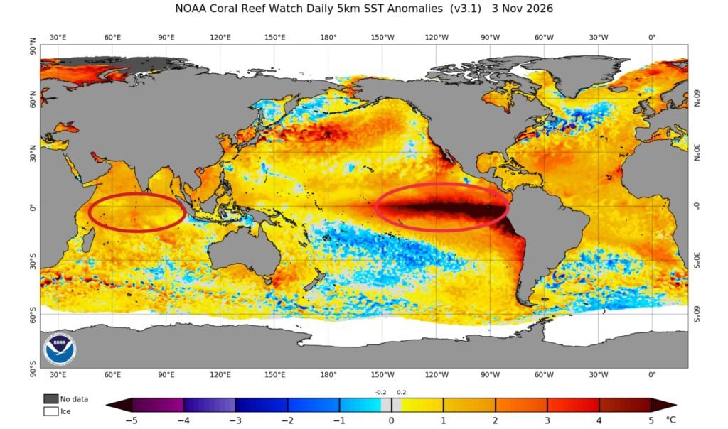
Considering the last 8 weeks of the Indian Ocean Dipole, a Positive IOD has firmly established over the Indian Ocean with moderate strength. Here are the official weekly values:
| Week Ending | Period | IOD Index |
| 1 Nov 2026 | 26 Oct – 1 Nov | +0.73 |
| 25 Oct 2026 | 19–25 Oct | +0.69 |
| 18 Oct 2026 | 12–18 Oct | +0.88 |
| 11 Oct 2026 | 5–11 Oct | +0.88 |
| 4 Oct 2026 | 28 Sep – 4 Oct | +0.59 |
| 27 Sep 2026 | 21–27 Sep | +0.75 |
| 20 Sep 2026 | 14–20 Sep | +0.68 |
| 13 Sep 2026 | 7–13 Sep | +0.63 |
The index has stayed continuously above the +0.4 °C positive threshold for these 8 weeks, peaking at +0.88 °C in early to mid October and still holding a solid +0.73 °C in the most recent week.
Bay of Bengal SST stays around 29–30 °C. Moderately strong Positive IOD with 30 °C SSTs is likely to stay favourable, and PIOD conditions are expected to continue developing further throughout November.
On the other side, record-breaking severe super El Nino conditions persist over the Pacific Ocean. The Niño 3.2 region has touched 30 °C (roughly 3.5 °C above average) and is likely to reach near 4.0 °C in the next few weeks. Overall, this is shaping up as a Severe Super El Niño driven year.
As a result of the Severe Super El Niño and moderate positive IOD with favourable SST, planetary waves are likely to be kept over the Indian Ocean for a prolonged time.
There are a few clear points why NEM can still end up with super excess:
- Streamlined flow of easterlies is just setting in over Southern Peninsular India. Onset created by the Sri Lanka low, typical easterlies flow has now arrived.
- Strong typhoon activity season will shut down soon. Hence, the full fledged moisture filled easterlies and ocean energy will not get shared or influenced away over the Indian Ocean.
- ITCZ is still in the Tamil Nadu & Sri Lanka latitude. Thanks to Murasu & Arnab for helping keep the ITCZ near our latitude.
- A fresh arrival of a Rossby wave followed by re emergence of Indian Ocean activity is likely to bring three back to back low formations over the Bay of Bengal between 15 November and 5 December 2026.
- Just look at how we suffered with below normal rain and extended summer conditions till 14 October. After 15 October only the entire Tamil Nadu started receiving decent rain the seasonal recovery is already underway.
Conclusion: Moderate Positive IOD (sustained +0.6 to +0.88 °C over the last 8 weeks) + Severe Super El Niño + warm Bay of Bengal & South China sea (29–30 °C) + establishment of streamlined easterlies = a favourable large scale setup for an active and potentially super excess Northeast Monsoon over southern peninsular India into November and December.
Let’s see how it unfolds..stay tuned with deltaweatherman.in

